Notional render of a lunar south pole habitat cluster, power station, and communications tower near Shackleton crater, with Earth and an orbital relay visible above the horizon

The cislunar corridor

On the Moon's far side, Earth stays below the horizon.

A lunar base is not reached by one radio link. Sightlines, relay orbits, and the speed of light itself have to be engineered together — a corridor from Earth's antennas to a rover behind a crater rim, a quarter million miles away.

Constraint: straight lines only Distance: 1.3 light-seconds Far side: Earth below horizon

01 · Line of sight

The scarce resource

Radio links do not bend around worlds. In cislunar space, the useful question is often simple: can one antenna see the next one?

The Moon is in synchronous rotation today: one turn per orbit, so the same hemisphere faces Earth. From farside surface sites, Earth stays below the local horizon; a relay is part of the terrain, not an optional upgrade.

At the poles the problem is subtler. Earth rides low on the horizon, moving only a few degrees with the Moon's slow nod. A crater rim, a ridge, or the wall of a lander can be enough to block the only line home.

Line of sight at the lunar south pole Earth low on the horizon, a relay overhead, a tower on the crater rim, and a rover cut off behind terrain. Earth, low on the horizon relay tower on the rim rover, below the rim direct line: blocked by the rim
Earth link is conditional Tower covers local terrain Relay restores the path

02 · Latency

Even at light speed, you wait

When the line of sight exists, physics still charges rent. A radio pulse covers the 384,400 km from Earth to the Moon in about 1.3 seconds — watch one make the trip below. The round trip is about 2.6 seconds: enough lag that "real time" control is already a stretch.

A radio pulse travelling between Earth and the Moon at light speed 1.28 s 2.56 s round trip Earth Moon
1.28 s Drawn to scale: the bodies and the gap.

This is why latency, not bandwidth, sets the autonomy budget. On Earth, operators run machines live. At the Moon, every command loop is 2.6 seconds wide, so spacecraft handle the reflexes and people handle the decisions. At Mars — 3 to 22 light-minutes away, depending on the year — joystick-style control gives way to planned sequences.

03 + 04 · Relay geometries

Two blind spots, two different relays

South-pole sites need a relay that dwells above low horizons. Farside sites need one that clears the lunar disc from Earth's point of view.

03 · South-pole dwell

Hold the southern sky

Problem

Low orbiters cross the sky quickly, then drop behind the Moon.

Geometry

An NRHO climbs high over the south pole and moves slowest there.

What it buys

Long dwell, Earth view, and a useful sky position for polar assets.

A near-rectilinear halo orbit dwelling over the lunar south pole, compared with a low lunar orbit to Earth south-pole site apolune: the slow, useful end of the lap
day 3.3 of 6.56 south-pole link: holding low orbiter: in view Distances compressed; the low orbit is shown slower than reality — its real contact windows are even briefer.
Why this orbit helps

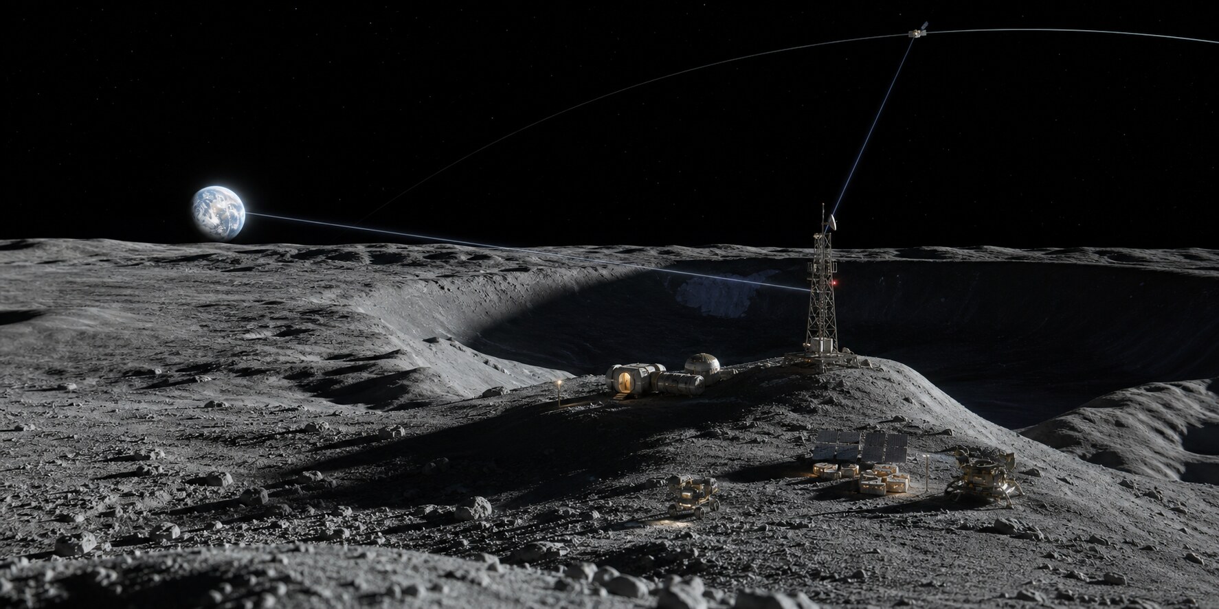
Near-rectilinear halo orbits belong to the halo families around the Earth-Moon balance points. Gateway's planned orbit swings within about 3,000 km of the north pole, then climbs to roughly 70,000 km above the south pole. Because orbital motion is slowest near that high point, the relay spends much of each 6.5-day lap in the part of the sky a south-pole site can use.

04 · Farside relay

Step off the shadow line

Problem

The Moon sits between a farside surface site and Earth.

Geometry

A relay loops around L2 instead of sitting on the centerline.

What it buys

Simultaneous visibility to Earth and the farside surface.

A relay in a halo orbit around the Earth–Moon L2 point keeps simultaneous lines of sight to Earth and a farside lander Earth Moon L2 farside lander relay AS SEEN FROM EARTH clear of the disc

The relay orbits the balance point instead of sitting on it. Seen from Earth, the halo loop clears the Moon's disc while still seeing the farside surface.

This is flown hardware, not a thought experiment. China's Queqiao relay has worked from a halo orbit around L2 since 2018, supporting the Chang'e-4 farside mission.

Distances compressed, geometry faithful.

Why the halo clears the disc

Seen from Earth, a halo orbit projects to a loop around the Moon's disc. Queqiao's path swings far enough out of plane that its apparent track clears the Moon's edge while maintaining visibility to the farside region it serves. The useful property is simultaneous geometry: Earth view and farside view at the same time.

05 · The corridor

Assemble the corridor

Turn the layers on and the route stops looking like one radio hop. It becomes a stitched path: ground antennas, relay orbits, local surface links, and a store-and-forward network that waits for the next scheduled contact.

End-to-end path All layers active
Earth–Moon communications corridor Deep-space antennas on Earth, a relay dwelling in a near-rectilinear halo orbit over the lunar south pole, a second relay in a halo orbit around L2 serving the far side, and a surface tower and mesh at the pole. deep-space antennas planned transfer arc south-pole tower + mesh farside site NRHO dwell relay L2 halo relay contact-plan routing stitches scheduled links into one corridor

In the coverage scenario behind this storyboard, one relay in a halo orbit around L2 removed the low-orbiter geometry gaps: the worst daily gap went from 21 minutes to zero. Three conventional relay satellites were needed to match that result.

How a network with breaks still delivers

Networks like this do not route the way the internet does. Link schedules are computed ahead of time from orbital geometry — a contact plan — and traffic waits out gaps onboard instead of being dropped. A message may ride a relay for twenty minutes before its next link rises. Delivery is decided by geometry first and software second, which is why the orbits above matter more than any protocol. That discipline — scheduled contacts, custody, store-and-forward — is what the Tolerant Interplanetary Network (TIN) research program formalizes and tests.

Go further

Fly the geometry yourself

The orrery is a small flyable solar system — the same orbital mechanics that shape the corridor, at full scale. WASD to fly, click a body to focus.

Open the orrery

The research program

The corridor has a paper trail

The network described above is not just a storyboard. TIN, the Tolerant Interplanetary Network project, builds and tests the routing layer it sketches: contact plans computed from geometry, store-and-forward custody, delivery decided by schedule rather than luck.

Alongside the code sits a conformance question: if you replay a network's frozen schedule, do the delivered outcomes come back unchanged? A white paper answers with preregistered statistical certificates rather than point estimates.

Browse papers and software

Scope note

Storyboard, not blueprint

The hero scene and diagrams are notional. The factual anchors are narrower: lunar geometry, light-time, the published Gateway orbit, and the flown Queqiao relay.

Commodity phase diagram showing feasibility boundaries by cargo half-life and transit time

Deep-space logistics

The Moon is the first corridor

The older propellant result is still the broader logistics frame. Before cargo becomes interplanetary, the Earth–Moon system has to be observable, commandable, and recoverable.

Read the covered wagon essay